One of the greatest things to originate out of the smartphone revolution was the advantage of having phones that have turn-by-turn navigation and maps right out of the box. You have a tool, in the palm of your hand, to take you straight away anywhere you want to go. GPS-supported devices have changed the previous concept of navigation and made us discard all those bits of paper in our pockets along with the extra time before leaving home of pondering over maps trying to work out where were we going. . There is a plenty of really good android navigation apps. So, we have listed the top apps in our list, choose the ones with the utilities to best suit you. Happy traveling!
Maverick Lite :
Maverick Lite is the awesome, top of the list navigation app that offers a lot of features. It includes maps from Google and Bing, off-road GPS navigator with OSM, in built compass and provision for offline maps . You can also save and then navigate to specific points, share your current or yet to be location and you can record and upload tracks to GPSies.com.
Maverick Pro :
Maverick Pro is the best GPS off-road navigation app for android devices . It is great for outdoor activities like hiking, geo caching and boating. It offers you off-road GPS navigator with OSM, Google and Bing maps, lookout speed, altitude, pitch and many other values of points and offline maps. It has an in built compass with the feature of sharing your location and direct to points. You can also record and upload tracks to gpsies.com.
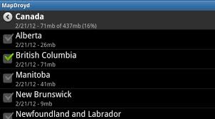
MapDroyd :
MapDroyd is one of the highest rated android navigation applications and the best thing about it is offline maps for the entire globe. You can explore the whole globe and search for places, just by a few clicks. Just type and search and you can track your location and any other location you want. It allows you to tilt or rotate you map view and it does not ends here you can have 2 D and 3D views of the map as well.
So download this application and feel the world in your pocket.
Let’s count its main features:
– Offline vector map rendering and search.
– Worldwide maps established on Open Street Map raw data.
-Free map downloads.
– Consistent map updates.
– Address and point search.
– Smart search.
– Tracking mode.
– Determines address at your current or explored position.
– Consist of a map download and update administrator.
– Customizable storage space.
Google Maps :
Google maps is the most renowned navigation application with a very user friendly interface. It helps you find your way with a speech directed turn-by-turn GPS navigation. It also tells you all types of routes like via car or walking etc. You can also get reviews from other people about a specific placeand get personalized references for all of those locations or directions. You can have 360 degree views of the route and see inside restaurants, bars and museums.
CoPilot Live Premium :
CoPilot as apparent from the name is one of the best satellite navigation applications specially designed for drivers. It gives you voice guided GPS navigation, you only need to say the location’s name and it will take you there. It gives you detailed street map and the maps are available offline as well. The most amazing features of copilot are:
* Driver-friendly.
* Safety-first.
* 12 months active trafficâ„¢ is included.
* Specially optimized for android.
* Local copilot.
* Detailed street maps included (UK& Ireland). 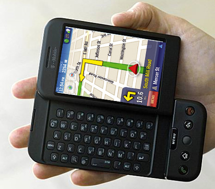
GPS Essentials :
GPS Essentials is the utmost wide-ranging GPS device in android market . It has forty five widgets. This app navigates, manages points, paths, directions and lets you make your personal customized dashboard.
Its dashboard indicates numerous navigation values which are:accuracy, altitude, speed, battery, bearing, climb, course, date, declination, distance, eta, latitude, longitude, max speed, min speed, actual speed, true speed, sunrise, sunset, moonset, moonrise, moon phase, target, time, turn.
It has a good compass as well as an oceanic compass. You can record tracks, export kml files and view them on Google earth and Google maps. You can also get turn by turn instructions. It has camera services, shows you points, allows you to take pictures and upload them.
UTM, MGRS, OSGB, Degree-Minute-Second, Degree-Minute-Fractions, Decimal and Mils are the supported formats. Way points, routes and tracks can be sent through email or uploaded to Google Docs or Drop Box.
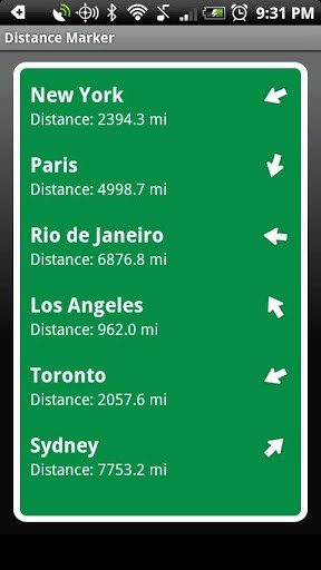
Distance Marker :
Distance Marker is the new android application for navigation which is best for road trips.
It presents a road mark with the distance and direction en route for your navigated place. It uses GPS positioning and compass for distance calculation and navigation. I8t uses conventional methods like mi, km as well as different methods such as ‘very far’ for telling distances.
It uses signs like vacationer styled landmarks and is a fun app.
Tube Map :
Tube Map is the world’s quickest route organizer giving way to your target. It has a lot of cool features like live arrival and departure information oyster balance check and station finder.
It main features are:
• Official licensed Tube map from London Transport
• Its Map includes all stations that support Oyster PAY G services
• Provides you Twitter integration
• Finds your closest station with no trouble.
Provides you live departure boards and station information.
Use this app and feel the difference.
Locus Map Pro :
GPS outdoor navigation with app Locus Map Pro supports you in your everyday life. Keep this application with you, check the directions and distance of your location and go wherever you want to go . This application offers you offline maps. You can get different sorts of cycling and hiking maps. It has intelligent GPS, supports full WMS maps, and supports OSM, SHO Cart, Free map, Smart Maps, MapQuest, Navig asi, NzTopoMaps, Turaterkep, Osmapa. pl, Chart Bundle and others. You can create your offline Vector maps, Open Street Map and custom style your maps, like color by altitude, and by speed etc. you can search by address, coordinates, and points and by Google places. It has online voice navigation. It works with KML, KMZ, GPX, OpenAir, and DXF formats. It also has an innovative system for deactivating GPS when needed to save battery. Have fun traveling!
Navfree :
Navfree is one of most popular application for transportation. It is an absolutely free navigation app that offers turn by turn directions, vocalized in addition to on screen instructions, offline map usage, address live search using Google and Microsoft Bing. All map downloads are free.
Some of its cool features are:
– It uses source map data from Open Street Map.
– Browse maps by dragging and scrolling.
– Provides you On-board maps
– Offers multiple guidance displays
– Switch between 2D and 3D mode.
– User friendly interface
– Day and night maps
– Music volume by design disappears when voice direction is played.
– It zooms automatically at junctions.
– It provides you a sample route plan
– Its special lists allow you to check each step of your journey.
– It has pedestrian navigation.
– Search by address or postcode of your destination.